The recent British military trials celebrating the conversion of a SYOS uncrewed surface vessel (USV) into a mobile radio frequency (RF) sensor platform are a masterclass in procurement theater. Navies around the world are rushing to mount passive electronic warfare arrays onto small autonomous boats, convinced they have discovered a cheap, expendable method to map the electromagnetic spectrum.
They are wrong. They are fighting the laws of physics, and physics is winning.
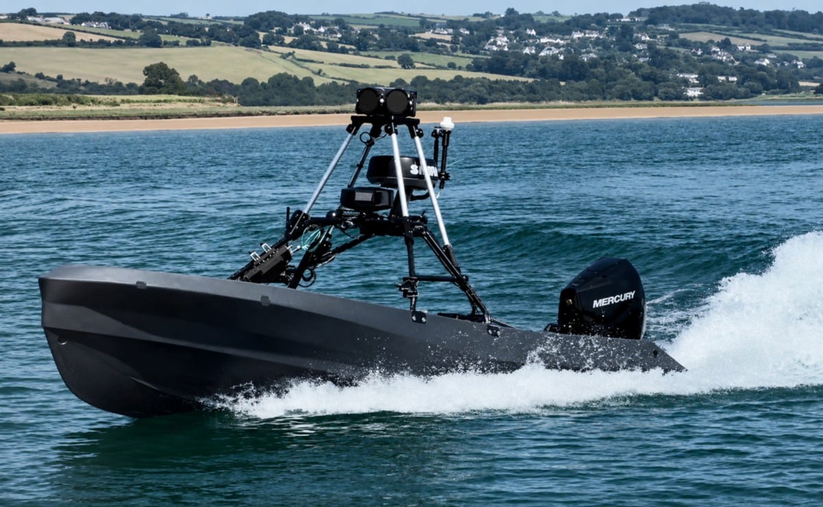
The concept sounds neat on a PowerPoint slide. You take a low-profile, New Zealand-built drone boat, bolt an RF receiver to the hull, and send it into contested waters to intercept enemy radar emissions and radio traffic without risking human life. The defense press laps it up, calling it a major leap forward for distributed maritime operations.
In reality, putting an RF sensor on a small boat sitting two feet above the waterline is one of the least efficient ways to collect signals intelligence.
The Fatal Flaw of the Waterline Horizon
The single greatest enemy of radio frequency sensing is the curvature of the Earth. Radio waves in the Very High Frequency (VHF) and Ultra High Frequency (UHF) bands—the exact bands used by military tactical radios and modern data links—rely primarily on line-of-sight propagation.
When you place an RF sensor on a small USV like the SYOS platform, your antenna height is severely constrained. A mast on a small drone boat might reach three to five feet above the water surface at best.
Let us look at the mathematics of the radio horizon. The distance to the horizon ($D$) in nautical miles can be calculated using the standard formula:
$$D \approx 1.23 \times \sqrt{H}$$
Where $H$ is the height of the antenna in feet.
For an antenna mounted five feet above the water, the horizon is a miserable 2.75 nautical miles away. Even if the target transmitter is located on a ship with a mast height of 50 feet, the maximum theoretical range for intercepting that signal is less than 12 nautical miles.
[Small USV with low mast] ──── (Blocked by Earth's Curvature) ────> [Enemy Transmitter]
       (2.75 nm Horizon)
Compare this to a cheap quadcopter or a tethered drone raised just 300 feet into the air. At 300 feet, the sensor’s horizon expands to over 21 nautical miles. By elevating the sensor slightly, you multiply the coverage area exponentially. Packing a delicate electronic warfare payload onto a surface drone means you are deliberately blinding your equipment before it even leaves the harbor.
The Pitch, Roll, and Triangulation Disaster
Intercepting a radio signal is only half the battle. To make that data useful, you must geolocate the source. Modern electronic support measures rely on Direction Finding (DF) techniques, such as Amplitude Comparison or Phase Interferometry, to calculate the Angle of Arrival (AoA) of an incoming wave.
These systems require extreme stability. They rely on micro-second differences in how a radio wave hits an array of closely spaced antennas.
Now, imagine mounting that sensitive antenna array on a small, lightweight hull being tossed around by a three-foot chop in the English Channel. The constant, violent motion of pitch, roll, and yaw constantly shifts the orientation of the sensor array relative to the horizon.
- Rotational errors: A roll of just a few degrees throws off the phase calibration between antenna elements.
- Dynamic calibration failure: While software can attempt to compensate for motion using high-grade Inertial Measurement Units (IMUs), the processing overhead is immense, and the margins for error in turbulent water remain dangerously high.
- Signal degradation: The proximity to the moving sea surface creates multipath interference, where the radio wave reflects off the water and hits the sensor multiple times, scrambling the data.
I have seen engineering teams spend millions trying to stabilize maritime sensor feeds, only to realize that a fixed land mast or a steady airborne platform solves the entire problem for a fraction of the cost.
The Transmission Paradox
The ultimate irony of the autonomous "stealth" RF sensor boat is its dependency on data backhaul.
A passive RF sensor is supposed to be silent. It listens to the environment without emitting energy, making it difficult for an enemy to track. However, a drone boat does not process complex signals intelligence locally with a tiny onboard computer; it needs to send that heavy raw spectrum data back to a command ship or a shore station.
How does it send that data? Through a wireless radio link or a satellite terminal.
The moment the USV transmits its findings, it ceases to be a passive, hidden scout. It becomes a screaming beacon in the middle of the ocean. Enemy electronic warfare units will detect the data link instantly, geolocate the USV, and target it. You have not created a stealthy scout; you have built an expensive, floating target that tells the enemy exactly where your intelligence collection efforts are focused.
Where Surface Drones Actually Belong
Am I saying uncrewed surface vessels are useless? No. But we need to stop treating them like a Swiss Army knife for every electronic warfare requirement.
USVs excel at payloads that physically require immersion in the water column. They are excellent platforms for active and passive sonar arrays, towed acoustic decoys, and mine countermeasures. If you need to hunt a submarine or clear a digital minefield, use a boat.
If you need to intercept a radio transmission or jam an enemy radar, get off the water and get into the sky. The future of mobile RF sensing belongs to high-altitude tethered balloons, low-cost attritable aerial drones, and distributed satellite constellations—not to a glorified jet ski bouncing blindly in the surf.