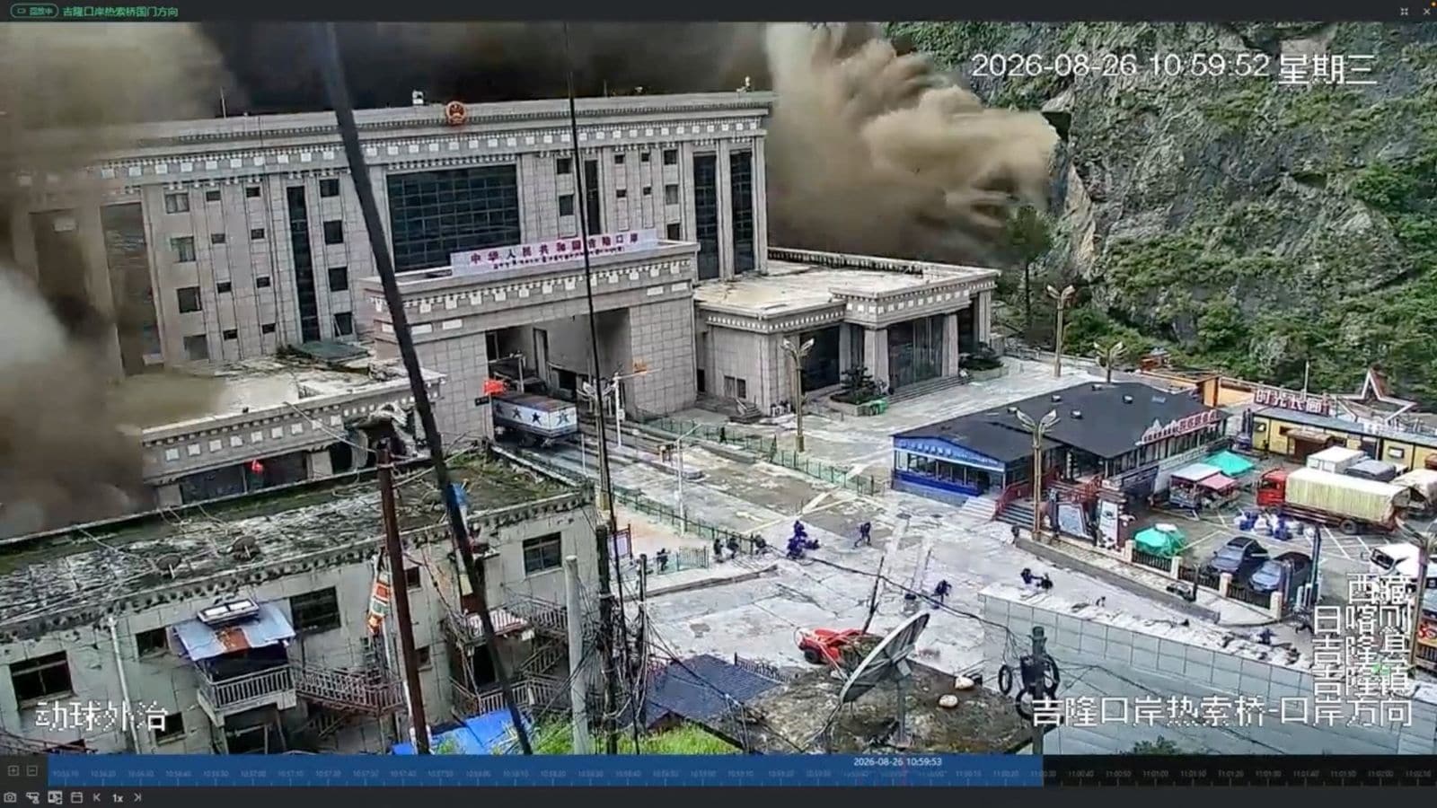
The catastrophic flash flood that roared down the Himalayan river valleys along the Nepal-Tibet border has left hundreds dead and thousands missing, exposing a grim reality where institutional opacity and cross-border geography collide. Official figures from Kathmandu confirm a rising death toll surpassing 470, with nearly 2,000 individuals unaccounted for across the region. Yet, while Nepalese authorities scramble through mud, debris, and severed infrastructure to tally the losses, the official narrative emanating from Beijing paints a starkly different, muted picture. This stark statistical divergence between neighbors sharing the same pulverized river basins is not merely an administrative discrepancy. It is a calculated exercise in information containment that leaves downstream communities vulnerable to secondary disasters.
Understanding the magnitude of this crisis requires looking beyond surface-level casualty counts to the structural vulnerabilities of the Third Pole. On a Wednesday morning, a massive glacial collapse high in the mountains registered as a magnitude 5.2 seismic event as millions of tons of ice, rock, and sediment slammed into the valley floor. This debris torrent instantaneously choked vital waterways like the Bhote Koshi and Trishuli rivers, transforming dry riverbeds and gentle streams into unstoppable walls of water and slurry. Entire settlements, tourist outposts, and multi-million-dollar hydropower installations were erased within minutes.
The Anatomy of a Cross-Border Information Blackout
When natural disasters strike high-altitude border regions governed by asymmetric political systems, transparency is often the first casualty. While Nepal's democratic institutions, despite being severely strained, provide daily updates and allow ground reporting from devastated zones like Rasuwa and Nuwakot, Beijing’s public reporting on the disaster inside the Tibet Autonomous Region remains tightly restricted. Chinese state media initially acknowledged only a handful of casualties, reporting minimal impact near the epicenter around Gyirong Port.
Rights groups and international observers have increasingly criticized this information gap, pointing out that minimizing the scale of upstream impacts obscures the true hazard profile of the entire watershed. Rivers do not recognize national boundaries. When debris blockages form natural barrier lakes in remote Tibetan gorges, the threat vector points directly south into the densely populated valleys of Nepal and northern India. By underreporting localized impacts and restricting independent hydrological assessments on the Tibetan plateau, authorities complicate downstream early warning systems. Emergency managers in Kathmandu are left guessing about the structural integrity of upstream natural dams formed by the glacial collapse.
Hydrological Realities on the Roof of the World
The mechanics of glacial lake outbursts and debris-flow floods are brutally straightforward, yet modern engineering struggles to mitigate them in high-altitude environments. Climate change has accelerated the melting and destabilization of Himalayan glaciers, creating thousands of unstable marginal lakes perched thousands of feet above populated valleys. When a collapse occurs, the resulting kinetic energy strips riverbanks bare, gathering mass and momentum over dozens of miles.
In the case of the recent disaster, the blockage near Gyirong Port created an unstable barrier lake at an elevation approaching 10,000 feet. As water pooled behind this chaotic dam of ice and boulders, the threat of a secondary catastrophic breach forced both nations to temporarily halt rescue operations. Rescuers wading through waist-deep mud were pulled back as sirens warned of an impending secondary washout.
This dynamic highlights a dangerous dependency. Nepal sits at the bottom of a steep hydraulic funnel, bearing the brunt of ecological shifts and upstream developments over which it has zero sovereign control. The expansion of infrastructure projects, roads, and hydropower facilities along transboundary rivers in Tibet alters sediment loads and natural drainage patterns. When a failure occurs upstream, the lack of real-time telemetry sharing leaves downstream communities with mere minutes to react.
The Human Toll and the Politics of Aid
Beyond the geopolitical friction lies an unfolding humanitarian emergency of staggering proportions. The missing list includes hundreds of foreign nationals, international tourists, pilgrims, and migrant workers who were caught off-guard in remote mountain passes and immigration facilities. Aid agencies report that entire communities have been wiped off the map, leaving no local survivors capable of organizing initial rescue responses.
Road connectivity has been obliterated across dozens of miles, forcing rescue coordinators to rely almost exclusively on rotary-wing aircraft. Helicopters ferry emergency food packets and medical supplies to stranded pockets while pulling survivors from precarious perches atop damaged industrial sites. However, mountainous weather patterns frequently ground these flights, stranding the injured in freezing, muddy conditions.
The reluctance of regional governments to fully open the floodgates to independent international technical assistance further complicates the recovery phase. While bilateral cooperation between Nepal and China on search operations has resumed following the temporary easing of the barrier lake threat, systemic trust is lacking. Geopolitical rivalries in the Himalayas frequently supersede scientific collaboration, treating hydrological data as state secrets rather than public safety essentials.
Living on Borrowed Time in Downstream Basins
The disaster serves as a harsh indictment of regional disaster risk reduction frameworks. For decades, scientists have warned that the Hindu Kush Himalaya region is warming at rates well above the global average, drastically increasing the frequency of glacial lake outburst floods. Yet, adaptation strategies remain reactive rather than proactive. Early warning sensor networks installed along transboundary rivers are sparse, fragile, and vulnerable to the very debris flows they are designed to detect.
As rescue operations transition into recovery and the grim task of identifying remains continues, the deeper institutional failures remain unaddressed. Downstream populations are left living on borrowed time, reliant on political whim and opaque bureaucracy for warnings about the very water shaping their existence. Unless regional powers treat ecological data as a shared humanitarian necessity rather than a geopolitical vulnerability, the next catastrophic surge down these mountain valleys will catch the world equally unprepared.