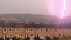
You probably woke up to a barrage of social media clips showing London looking like a sci-fi movie set. For a solid window overnight, the sky didn't just flash—it vibrated. The Met Office recorded over 29,000 lightning strikes across southern England during a hyper-intense 24-hour window, throwing local infrastructure into absolute chaos.
If you think this was just a standard British summer downpour, you missed what actually happened. The sheer scale of this storm cluster makes it one of the most intense electrical events the region has seen in years, peaking at over 500 lightning strikes per minute.
The Ground Zero Nobody Saw Coming
While Londoners got the best view on X and TikTok, the real damage hit further west. Somerset bore the absolute brunt of the storm system. The county was hammered by 18,540 individual strikes, turning rural communities into temporary lakes.
The disruption wasn't just a matter of flickering lights. It completely broke down daily routines.
- River Levels: The Environment Agency issued immediate warnings as the River Sheppey began rising rapidly, threatening areas like Shepton Mallet, Croscombe, and Fenny Castle.
- Grid Failure: The National Grid reported hundreds of homes losing power instantly, with 331 properties left in the dark in Glastonbury and another 252 in Shepton Mallet.
- Retail Chaos: Local infrastructure simply couldn't cope with the flash flooding. Major supermarkets, including Tesco locations in Glastonbury, Wells, and Shepton Mallet, had to shut their doors as floodwaters breached the entrances. Staff worked straight through the night just to dry out the aisles.
The Science Behind the Chaos
This wasn't some random bad luck. The meteorology behind the June 22 storm system required a specific recipe of atmospheric instability.
It started when a plume of incredibly warm, humid air surged north from continental Europe. At the same time, an unusually cold air mass was sitting high up in the upper atmosphere over the UK. When that warm air hit the cold block, the atmosphere shattered what meteorologists call the "cap"—a layer of stable air that usually keeps storms from growing.
Once that cap broke, the result was explosive. Strong updrafts pushed storm clouds past 40,000 feet, carrying massive amounts of ice particles and moisture into sub-zero temperatures. As these ice crystals violently collided, they generated an immense electrical charge. The atmosphere essentially became a giant battery that had to discharge, leading to the continuous flashes that kept millions of people awake.
Why Our Infrastructure Keeps Failing
Every time a storm like this hits, the same question pops up: why does a couple of hours of rain paralyze British towns?
The answer comes down to our drainage capacity. Most suburban drainage systems in the West Country are designed for steady, prolonged rain—not tropical-style convective downpours. When you dump an entire month's worth of water onto baked, hard summer ground in less than an hour, the water has nowhere to go. It runs straight off the fields and into the streets, overwhelming the local sewers instantly.
If you live in an area prone to surface water flooding, you can't rely on local councils to react in time. The smartest thing you can do right now is check your property's immediate vulnerability. Clear your own guttering and any street gullies right outside your driveway. If your home sits lower than the road level, keeping a few heavy-duty flood bags or sandbags stored in the garage isn't dramatic anymore—it's essential insurance against the next atmospheric breakout.