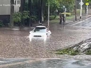
Waymo halted its entire driverless operations in Atlanta after multiple autonomous vehicles drove directly into flash floods. The shutdown occurred after an unoccupied Jaguar I-PACE became stranded in deep water in Midtown, while another vehicle carrying a local journalist repeatedly drove into flooded lanes, forcing remote operators to assist. This is not an isolated weather incident. It exposes a fundamental flaw in how the tech giant identifies pooling water, occurring just days after a federal recall of 3,791 vehicles for the exact same issue.
The grounding of the Atlanta fleet, alongside an active suspension in San Antonio, reveals a critical blind spot in the multi-billion-dollar race for autonomous ride-hailing. Software can read road signs, track erratic pedestrians, and calculate defensive driving maneuvers in milliseconds. Yet, it remains baffled by a few inches of murky water.
The Blind Spot of the Machine
The hardware suite anchoring the Waymo Driver platform relies on a combination of radar, cameras, and lidar. These high-definition sensors bounce laser beams off surfaces to construct a three-dimensional map of the environment.
This works brilliantly on dry pavement. It fails when encountering standing water.
Water behaves unpredictably when hit by light and lasers. To a lidar sensor, a deep, muddy puddle can look identical to flat asphalt because the water absorbs or specularly reflects the laser pulses away from the receiver. Instead of reading a hazard, the vehicle sees a clear path. Cameras struggle with depth perception when a road surface turns mirror-like, blending the reflections of streetlights, gray skies, and surrounding buildings.
A human driver evaluates a flooded road through context. We see ripples, splashing from other vehicles, or the disappearing base of a fire hydrant. The autonomous vehicle processes pixels and point clouds. Without explicit data indicating depth, the computer defaults to its pre-mapped understanding of the road.
The Software Patch That Failed
The recent chaos in Georgia arrived immediately after Waymo attempted to address the vulnerability. Following an April incident where an unoccupied robotaxi was swept into a creek in Texas, the company issued a voluntary recall with the National Highway Traffic Safety Administration.
The interim solution was not a complete rewrite of the vehicle's perception stack. Instead, the company introduced geographic restrictions. The software update restricted vehicles from entering areas with an elevated risk of encountering a flooded, higher-speed roadway during heavy rain.
This approach shifts the burden of detection from the vehicle's onboard sensors to external weather data.
When an intense downpour hit Atlanta during rush hour, the local infrastructure became overwhelmed long before official government channels caught up. Waymo confirmed that its vehicles plunged into the rising waters before the National Weather Service issued a formal flash flood warning. Because the digital alert did not exist, the vehicles treated the routes as safe.
A technology that promises to be safer than a human driver cannot rely on federal weather bulletins to know if it is raining.
The Disconnect of Remote Support
When a robotaxi becomes confused, it does not have a human driver to improvise. It stops.
During the Atlanta storms, an Atlanta Journal-Constitution videographer experienced this logic loop firsthand. The vehicle she was riding in repeatedly drove into flooded lanes at normal speeds, jerked to a stop under a bridge, and got stuck.
Waymo emphasizes that its vehicles cannot be remotely driven or piloted. Instead, a fleet response team monitors the cars from a distance. These operators can suggest maneuvers or provide contextual information, essentially telling the car, "it is safe to reverse now."
This creates a dangerous bottleneck in an emergency. In a flash flood, seconds matter. Waiting for a remote operator to review video feeds, approve a reverse maneuver, and clear a vehicle out of a rising current introduces a level of friction that a human behind the wheel would never face. If the vehicle loses its cellular connection due to storm interference, that remote support link breaks entirely.
The Geography of Autonomous Testing
The current crisis underscores why the autonomous vehicle sector has spent years clustered in the American Southwest. Phoenix, San Francisco, and Austin offered predictable, dry climates where edge cases involving weather are rare.
Expanding to the American South and East Coast introduces a completely different operational reality.
- Subtropical Downpours: Rain in Georgia or Florida does not drizzle; it drops inches of water in minutes.
- Aging Infrastructure: Outdated storm drain networks turn urban intersections into temporary lakes within half an hour.
- Topography: Sudden elevation changes and underpasses create localized traps that do not show up on standard digital maps.
By rushing to scale its partnership with Uber and deploying fleets into broader commercial markets, the industry is confronting environmental realities that cannot be simulated away in a California data center.
The National Highway Traffic Safety Administration is already investigating Waymo over separate incidents involving low-speed collisions and erratic behavior around school buses. This recurring inability to handle standing water adds intense regulatory pressure to an industry facing deep public skepticism. Software updates can patch a bad line of code, but teaching a computer to respect the raw, unpredictable physics of a flash flood remains a steep mountain to climb.