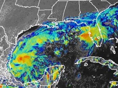
Meteorological forecasts tracking tropical systems often fixate on maximum sustained winds, but the speed and trajectory of a storm dictate its true destructive potential. When Hurricane Isaias tracked northward toward the United States coastline in August 2020, standard models initially struggled to pin down whether it would maintain its structural integrity over land or succumb to upper-level wind shear. For coastal communities from the Carolinas up to the Northeast, the core question was not merely whether Isaias would strike as a hurricane, but how its unusually fast forward motion would compress the hazard zone.
Understanding why Isaias behaved the way it did requires looking at the mechanics of upper-level steering currents. The storm formed from a robust tropical wave that moved off the African coast, eventually organizing into a tropical storm south of Puerto Rico. As it traversed the Caribbean and brushed Hispaniola and the Bahamas, terrain interaction disrupted its inner core. Yet, the system retained a remarkably compact circulation. When a tropical cyclone moves rapidly—often clocked at over 30 miles per hour in Isaias's case—it compresses the spatial distribution of heavy rainfall and wind threats. Forward speed acts as an additive force on the right-hand side of the storm's track, meaning the eastern semicircle absorbs significantly higher wind velocities.
Forecasting these anomalies exposes the persistent friction between numerical weather prediction models and real-time atmospheric observations. Forecasters at the National Hurricane Center continually balance satellite telemetry, reconnaissance aircraft data, and environmental shear indices. In the days leading up to the North Carolina landfall, dry air entrainment and westerly shear fought a persistent tug-of-war with the warm surface waters of the Gulf Stream. Traditional intensity models flashed contradictory signals. Some outputs suggested rapid weakening upon approach, while high-resolution regional models detected a brief window where the upper-level wind shear would relax just enough to allow re-intensification.
That exact structural recovery occurred right at the coastline. Isaias re-acquired hurricane status just hours before pushing ashore at Ocean Isle Beach, North Carolina, packing maximum sustained winds near 85 to 90 miles per hour. Because the system moved with such tremendous velocity, it did not linger long enough to drop catastrophic, historic rainfall totals in any single inland spot, which spared the region from the multi-foot flood disasters seen with slower, stalled systems like Hurricane Florence. Instead, the primary hazard morphed into widespread wind damage and an aggressive storm surge along the immediate waterfront.
Infrastructure vulnerabilities miles away from the initial splash zone quickly became apparent. As Isaias accelerated northeastward, it merged with an approaching mid-latitude cold front. This dynamic transformation supercharged the storm's wind field, allowing tropical-storm-force gusts to punch deep into the Mid-Atlantic and New England states. Millions of utility customers lost power, particularly in states like New Jersey, New York, and Connecticut, where dense suburban canopies of mature hardwood trees tangled easily with high-velocity wind gusts. Furthermore, the interaction with the cold front sparked a significant tornado outbreak, spawning dozens of twisters across multiple states, including a destructive EF3 tornado in North Carolina.
Emergency management agencies and utility providers face an uphill battle when fast-moving systems expand their footprint in this manner. Standard resource pre-positioning assumes damage will concentrate near the immediate landfall corridor. When a system retains its punch hundreds of miles inland, disaster response logistics stretch thin. Municipalities far from the coast found themselves unprepared for extended grid failures and blocked roadways caused by thousands of fallen utility poles.
Preparedness frameworks must continually adapt to these multi-hazard hybrid events. Meteorologists continue refining regional wind-shear detection models to provide earlier warnings for rapid, late-stage re-intensification cycles. Meanwhile, local infrastructure operators are forced to rethink grid resiliency in the face of compounding wind and severe weather threats that disregard traditional climate zones.