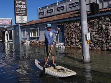
King tides inundate coastal streets and push saltwater into homes and businesses along both US coasts because perigean spring tides ride on top of higher baseline sea levels and regional ocean currents. Water does not need a hurricane to wreck a neighborhood. Sometimes it just needs a bright sky, a full or new moon aligned with perigee, and a storm drain system built for a lower ocean.
Standard coastal reporting treats these events like freak weather. That is lazy journalism. King tides are predictable astronomical alignments, timed years in advance by orbital mechanics, yet municipalities from South Florida to the Pacific Northwest still act surprised when seawater bubbles up through manholes on dry, sunny afternoons. When you spend enough years covering municipal budgets, infrastructure bond measures, and coastal real estate, a pattern jumps off the ledger: the water is rising faster than municipal balance sheets can adapt, and the hardest hits often happen on clear days when nobody is watching the radar.
What Actually Drives King Tides on Two Coasts
Astronomers call them perigean spring tides. Coastal residents just call them king tides, and the name fits when brackish water laps against porch steps.
The mechanics are straightforward. Twice a month, during a full or new moon, the sun, moon, and Earth line up so their gravitational pulls reinforce one another, creating larger-than-average tidal ranges known as spring tides. When the moon simultaneously reaches perigee—its closest orbital point to Earth—that gravitational tug intensifies further. Add Earth's seasonal tilt and closer approach to the sun in late autumn and winter, and you get the highest astronomical tides of the year.
Gravity is only half the equation. Ocean physics does the rest.
Water responds to atmospheric pressure and wind like a giant, sluggish fluid scale. Low barometric pressure pulls the ocean surface upward slightly, while persistent onshore winds push water toward the shoreline and pile it against bays, inlets, and barrier islands. Even a modest breeze blowing into a shallow harbor can add several inches—or more than a foot—onto an already elevated high tide.
East and West Coast dynamics look very different on the ground. Along the US Atlantic and Gulf coasts, broad continental shelves, low-lying barrier islands, porous limestone geology in places like South Florida, and regional ocean circulation shifts can amplify water levels dramatically. Along the Pacific Coast, steeper shelves and narrow beaches behave differently, yet seasonal winter swell trains, El Niño or La Niña ocean temperature shifts, and king tides still overtop seawalls, flood low-lying bayside roads, and chew away at bluffs.
| Factor | Mechanism on Water Levels | Typical Coastal Effect |
|---|---|---|
| Orbital alignment | Sun and moon align near lunar perigee | Amplifies high-tide peaks and low-tide troughs |
| Wind and barometric pressure | Onshore winds and low air pressure | Adds extra inches above predicted tide charts |
| Regional oceanography | Currents, eddies, and seasonal warming | Raises baseline water levels for weeks or months |
| Local land and drainage | Subsidence, porous rock, aging outfalls | Allows saltwater intrusion and street backflow |
Why Sunny Day Flooding Breaks Real Estate and Municipal Math
Ask a city engineer what fails first during a king tide and they will rarely point to the beach. They will point underground.
Stormwater pipes in coastal towns were overwhelmingly engineered to drain rainwater from streets out to the bay or ocean by gravity. When the receiving water body sits higher than the pipe outlet, gravity loses the argument. Instead of draining streets, storm drains turn into reverse fountains, pushing saltwater straight up onto asphalt and lawns even when not a single drop of rain has fallen.
Saltwater changes the damage calculus immediately. Fresh rainwater leaves mud and puddles. Saltwater leaves corrosive residue that eats into vehicle undercarriages, rusts electrical junctions and junction boxes, degrades concrete reinforcement over time, and kills landscaping that was never meant to see brine. For small businesses along low-lying commercial corridors, repeated nuisance flooding does not need to collapse a roof to ruin a quarter; it just needs to keep customers away for three days at a time and force constant repairs on delivery vans, HVAC units, and storefront thresholds.
A neighborhood does not have to be permanently underwater to become financially unviable. Recurring saltwater inundation wears down property value, infrastructure, and civic patience one tide cycle at a time.
Insurance and lending markets feel that friction long before city councils pass new ordinances. Flood insurance pricing under the National Flood Insurance Program's Risk Rating 2.0 methodology evaluates individual property risk—including distance to water, first-floor height, and varied flood frequencies—rather than relying solely on traditional flood zone lines. Meanwhile, private insurers in high-exposure coastal zip codes have pulled back, raised deductibles, or tightened underwriting standards.
Property owners often discover a painful gap when looking at losses. Standard homeowners policies generally exclude flood damage, and even flood policies often distinguish between sudden flood events and gradual wear, seepage, or maintenance issues. When water backs up through an unmaintained lateral line or seeps slowly into a crawlspace during consecutive high tides, arguments over coverage and causation get messy fast.
Consider a hypothetical example of a coastal rental duplex built in the 1970s on a low-lying lot. The structure sits just above the base flood elevation on paper, so its owners never experienced catastrophic storm surge during their first decade of ownership. Over the past five years, however, seasonal king tides have pushed water into the street and driveway six to eight times a year, saturating the yard, backing up a low yard drain, and corroding an outdoor AC condenser. Each individual bill looks manageable—a few hundred dollars for salt cleanup, a pump repair, or a replaced compressor—until annual operating expenses climb while tenants complain about damp odors and blocked access.
The Blind Spots in Coastal Defense Playbooks
Walk through a public meeting in a coastal municipality and you will hear two competing slogans. One camp demands hard infrastructure: taller seawalls, bulkheads, pump stations, and backflow preventers. The other camp pushes nature-based solutions and managed retreat: living shorelines, marsh restoration, mangrove buffers, and buyouts for the most vulnerable parcels.
Both sides have real points, and both sides routinely gloss over uncomfortable trade-offs.
Seawalls and bulkheads can block water from reaching a specific street or lot on a calm high tide. They are not magic shields. Water can still flank an unimproved neighbor's parcel, percolate upward through porous ground in karst terrain, or overtop a wall when a king tide coincides with a coastal storm. Worse, hard vertical walls can reflect wave energy downward, scouring the sediment at the base of the wall and eroding adjacent beaches or marshes that previously absorbed wave force.
Pump stations solve one problem while creating another. Pumping millions of gallons of saltwater out of flooded streets into a nearby canal or bay requires serious electrical capacity, backup generation, routine maintenance, and a place to put the water that does not simply flood a neighboring district. In some low-lying communities, aggressive pumping on one side of town can shift water stress elsewhere if drainage basins are poorly interconnected.
Nature-based buffers—like salt marshes, oyster reefs, and dunes—absorb wave energy and store water without turning the coast into a concrete canyon. Yet marshes need room to migrate inland as water levels rise. Along heavily built-out stretches of both US coasts, roads, seawalls, and private lots sit right behind the marsh edge, squeezing wetlands into a narrowing strip until they drown.
Buyouts and retreat sound rational on paper when taxpayer money goes toward repeatedly repairing the same flooded blocks. In practice, they collide with deep human attachment, local tax-base anxieties, and uneven buyout offers that sometimes leave homeowners unable to buy an equivalent home nearby without taking on new debt. A municipality that relies on voluntary buyouts can end up with a patchwork of empty lots next to occupied homes, complicating street maintenance, utility service, and emergency access.
What Smart Cities and Property Owners Actually Do Differently
The places handling coastal flooding best are not pretending they can freeze the tide chart. They treat high-water events as an operational calendar rather than a surprise.
Municipalities that make real progress usually start with data and plumbing before pouring concrete. That means pairing high-resolution tide gauges and street-level sensors with clear public triggers—closing vulnerable roads early, staging tow trucks and emergency vehicles outside low pockets, and installing backflow valves on municipal storm outfalls where elevation allows. It also means updating building codes and subdivision rules so new construction or major renovations account for higher future water levels rather than anchoring standards to historical averages that no longer hold.
For homeowners and commercial operators on either coast, practical preparation comes down to elevation, drainage, and documentation:
- Check true elevation, not assumptions: Look up elevation certificates, survey data, and local flood maps, and measure how high your lowest floor, garage slab, and critical mechanical gear sit above street grade.
- Elevate vulnerable equipment: Move HVAC condensers, electrical panels, water heaters, and pool or irrigation controls onto raised platforms or upper levels where feasible.
- Keep drainage clear and test backflow protection: Clear leaves and debris from swales, yard drains, and gutters before seasonal peak tides, and ask a licensed plumber or engineer whether backwater valves make sense for your plumbing layout.
- Separate flood coverage from standard policies: Review flood policy limits, waiting periods, and exclusions well ahead of peak tide seasons so you are not guessing what is covered after water enters a structure.
- Document conditions with timestamps: Take dated photos and videos of high-water marks, street flooding, and property conditions during king tide events to support insurance claims, municipal reporting, or code compliance records.
None of those steps stops the moon from pulling on the oceans. They simply keep a predictable astronomical cycle from catching people flat-footed—and keep a sunny afternoon puddle from turning into a financial crisis.
When the next round of king tides lines up on the calendar, look past the photos of flooded palm trees and boardwalks and check who is paying to pump the water out of the storm drains.