Linear measurements of fluvial systems systematically misrepresent their geopolitical, economic, and ecological utility. While public discourse prioritizes length as the definitive metric of a river system, a rigorous analysis requires evaluating a three-variable matrix: linear extent, volumetric discharge rate, and sediment transport capacity. These variables dictate the carrying capacity of agricultural hinterlands, the viability of trade corridors, and the structural limits of sovereign governance.
A comparative evaluation of the world’s nine longest river systems demonstrates that the geographic layout of a waterway establishes a foundational template for human settlements, which societies must continuously manage through engineering and infrastructure.
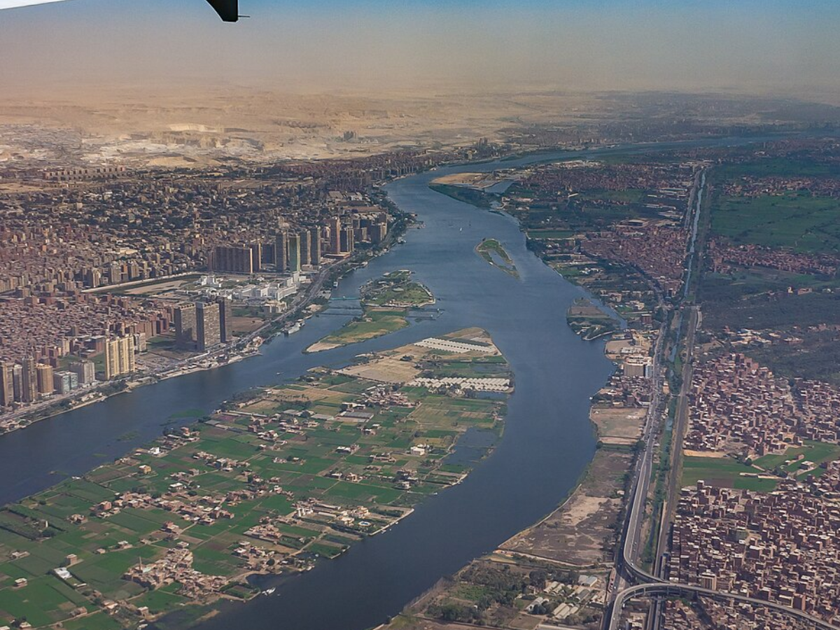
1. The Nile System: Linear Extremes and Asymmetrical Geo-Dependencies
The Nile River system, extending 6,650 kilometers, operates as a hyper-elongated linear oasis through the hyper-arid Sahara. Its structural mechanics rely on a critical structural asymmetry between its two primary components: the White Nile and the Blue Nile.
[White Nile: Low Volume, Steady Flow] ---\
                                          +---> [Main Nile Basin] ---> Mediterranean
[Blue Nile: High Volume, Monsoon Surge] --/
The White Nile maintains a highly stable, low-volume discharge due to the regulatory damping effect of Great Lakes reservoirs like Lake Victoria and the Sudd wetlands, which suffer vast evaporative losses. Conversely, the Blue Nile, originating in the Ethiopian Highlands, delivers over 80 percent of the total downstream volume, driven by seasonal monsoons.
This hydrological split created a predictable, seasonal pulse of water and nutrient-dense silt that allowed early Egyptian societies to develop highly organized farming. Because rainfall was virtually non-existent, local governance had to organize around the river's precise flood cycles.
The Geopolitical Bottleneck
The contemporary Nile Basin is defined by an allocation bottleneck. The 1959 Nile Waters Agreement granted near-exclusive volumetric rights to Egypt and Sudan, omitting upstream nations entirely.
The construction of the Grand Ethiopian Renaissance Dam (GERD) on the Blue Nile exposes the frailty of this historical legal framework. By capturing and controlling the headwaters that supply the vast majority of Egypt's water, Ethiopia has shifted the regional balance of power. The downstream consequences involve a strict trade-off between upstream energy production and downstream agricultural security.
2. The Amazon Basin: Volumetric Dominance and the Frictional Cost of Geography
The Amazon River measures approximately 6,400 to 6,575 kilometers, yet its defining metric is a mean discharge rate of 209,000 cubic meters per second ($m^3/s$). This exceeds the combined output of the next seven largest rivers. Draining an area of 7 million square kilometers, the Amazon functions as a massive drainage network that handles roughly 20 percent of global river runoff.
Fluvial Discharge = Basin Area × Effective Rainfall
The Amazon represents the upper limit of this formula, where immense geographic scale combines with intense equatorial precipitation.
Unlike the Nile or the Yangtze, the Amazon did not spawn a centralized, agrarian state. The interaction of high rainfall, acidic oxisol soils, and dense rainforest created a high-friction environment for transport and large-scale farming. Silt accumulation is largely confined to the immediate floodplains, while the surrounding upland soils remain deeply leached of nutrients.
Consequently, human settlements developed as decentralized, low-density networks along navigable channels. The river operated primarily as an extraction corridor rather than a continuous agricultural foundation, a pattern that still shapes modern industrial logistics in South America.
3. The Yangtze Corridor: The Industrial Engine and Technological Subjugation
The Yangtze River flows for 6,300 kilometers entirely within China, draining a fifth of the nation’s landmass. This watershed anchors an industrial and agricultural zone that supports over 400 million people. The river acts as a geographic axis that divides and connects northern and southern China.
The Yangtze's high discharge volume ($31,900\ m^3/s$) and extensive navigable main stem made it a premier trade corridor. However, its volatile flood cycles historically required massive engineering interventions.
Infrastructure and Risk Shifting
The construction of the Three Gorges Dam represents the ultimate expression of technological river management. The dam uses a concrete gravity wall to alter the river's natural flow, generating up to 22,500 megawatts of electricity while standardizing downstream water levels to permit year-round navigation by deep-draft vessels.
This engineering introduces a complex set of structural trade-offs:
- Sediment Trapping: The reservoir captures millions of tons of silt annually, accelerating the erosion of the Yangtze Delta downstream and reducing nutrient deposition in coastal fisheries.
- Seismic and Induced Risks: The weight of the 39 billion cubic meter reservoir alters local tectonic stress profiles, raising the frequency of minor seismic events and landslide hazards along the river's steep banks.
4. The Mississippi-Missouri System: The Geopolitical Foundation of North American Hegemony
The Mississippi-Missouri-Jefferson river system covers 6,275 kilometers and drains 3.2 million square kilometers across 32 US states and two Canadian provinces. This network forms the largest contiguous patch of arable land on earth.
From a geopolitical standpoint, the Mississippi system provided the United States with two major strategic advantages:
- Low-Cost Inland Logistics: The river network matches up directly with prime agricultural zones, allowing low-cost barge transportation to move bulk goods directly to global maritime trade routes via the Gulf of Mexico.
- Natural Internal Integration: The overlapping paths of the Missouri, Ohio, and Arkansas rivers created a unified domestic market long before interstate highways or transcontinental railroads were built.
The system requires constant intervention by the US Army Corps of Engineers. Through an extensive network of levees, wing dams, and the Old River Control Structure, the state works to prevent the Mississippi from taking a shorter, steeper path down the Atchafalaya River. This artificial stabilization keeps multi-billion dollar industrial hubs like New Orleans and Baton Rouge connected to global trade routes, though it requires continuous capital investment to counter natural delta shifting.
5. The Yenisey-Angara-Selenga System: The Cold-Regime Transport Barrier
Flowing 5,539 kilometers from Mongolia through central Siberia to the Arctic Ocean, the Yenisey system moves $20,200\ m^3/s$ of water. Its behavior is strictly dictated by sub-zero temperatures and northern geography.
The Yenisey suffers from a structural mismatch between its flow direction and human economic hubs. Because the river flows north into an ice-locked Arctic estuary, it cannot easily serve as a primary route for international shipping.
Furthermore, the river experiences severe spring breakup floods. The southern headwaters thaw weeks before the northern, downstream stretches clear of ice. This temperature difference causes massive ice dams to form, backing up water and flooding vast swathes of the Siberian taiga every year.
Southern Thaw (Water Inflow) + Northern Ice Jam = Severe Upstream Backwater Flooding
While the river’s massive drop in elevation supports heavy industrial power generation—feeding aluminum smelters via dams like Krasnoyarsk and Sayan-Shushenskaya—its extreme seasonal freeze cycles prevent it from serving as a reliable transit corridor for deep population integration.
6. The Yellow River: The Silt Trap and the Cycle of Dynastic Disruption
The Yellow River (Huang He) runs for 5,464 kilometers through northern China. It is defined by its extreme sediment load, carrying an average of 1.6 billion tons of silt annually as it cuts through the highly erodible Loess Plateau.
High Silt Load -> Channel Aggradation -> Perched Riverbed -> Catastrophic Avulsion
This heavy sediment load drives a volatile cycle of riverbed buildup. As the river slows down on the flat eastern plains, the silt drops to the bottom, raising the riverbed. To prevent flooding, societies have built high levees along the banks. Over centuries, this process created a "perched river," where the water flows dozens of meters above the surrounding countryside.
[Image cross-section of a perched river showing riverbed elevated above surrounding land]
When a flood breaches these levees, the river shifts its path entirely, carving out a new course to the sea that can sit hundreds of kilometers away from the old mouth. These catastrophic changes have caused millions of deaths over millennia, frequently triggering widespread famine, economic collapse, and the fall of ruling dynasties. The Yellow River demonstrates that a water source can build agricultural wealth while presenting a constant threat of sudden infrastructure failure.
7. The Ob-Irtysh System: The Siberian Lowland Conundrum
The Ob-Irtysh system extends 5,410 kilometers across Western Siberia, draining a vast, flat basin of nearly 3 million square kilometers. Like the Yenisey, its waters flow northward into the Arctic Ocean.
The defining feature of the Ob-Irtysh is the exceptionally flat terrain of the West Siberian Plain. With very little slope to pull water down to the sea, the river slows to a crawl, creating the Vasyugan Swamp—one of the largest wetland systems in the world.
During the spring thaw, the combination of melting snow and downstream ice dams turns millions of hectares into an impassable seasonal lake. While the system holds immense natural gas and petroleum deposits beneath its basin, extracting and moving these resources requires navigating deep mud and long periods of seasonal isolation, keeping population density very low.
8. The Río de la Plata Network: The Industrial Corridor of the Southern Cone
The Paraná-Paraguay-Río de la Plata system stretches 4,880 kilometers through Brazil, Paraguay, Bolivia, and Argentina. It serves as the primary economic transport link for the Southern Cone of South America.
Unlike the Amazon, this network cuts through subtropical and temperate agricultural zones, making it vital for regional trade. The Paraguay-Paraná Hidrovía functions as an open industrial channel, allowing landlocked Paraguay and inland Bolivia to ship agricultural commodities out to deep-water Atlantic ports.
Managing this system requires balancing the competing needs of upstream hydroelectric power production—anchored by massive facilities like the 14-gigawatt Itaipu Dam—with the need to dredge downstream channels to keep them clear for deep-draft cargo ships. The river system acts as a shared economic spine, meaning changes in upstream water management directly impact transport costs and trade balances for downstream nations.
9. The Congo System: The Dual-Hemisphere Hydro-Engine
The Congo River runs for 4,700 kilometers, but its strategic value stems from its position as the second-largest river in the world by volume ($41,400\ m^3/s$) and the deepest recorded river on Earth, reaching depths over 220 meters.
Northern Tributaries (Rainy Season A)  \
                                        +---> Stable, Year-Round Main-Stem Flow
Southern Tributaries (Rainy Season B)  /
The Congo is uniquely stable because its basin sits directly across the equator. The rainy seasons of its northern and southern branches balance each other out perfectly; when northern streams run dry, southern tributaries fill up, giving the main river a remarkably steady flow year-round.
The Inga Shallows Bottleneck
Despite its massive volume and steady flow, the Congo did not become an open highway for early maritime trade. Just before reaching the Atlantic Ocean, the river drops down the Livingstone Falls—a 350-kilometer stretch of intense rapids that blocks all ocean-going ships from traveling inland.
This geographic barrier isolated the interior of the continent from direct ocean trade for centuries, requiring costly rail links to bypass the rapids later on.
Today, this drop represents a massive opportunity for clean energy. The Inga Falls section holds the potential for the Grand Inga project, a massive proposed hydroelectric installation. If fully built out, it could generate over 40,000 megawatts of electricity, enough to power a significant portion of the African continent. However, realizing this potential requires navigating deep political fragmentation and the high capital costs of building large-scale infrastructure in a complex regulatory environment.
Quantitative Matrix of the Nine Major Fluvial Systems
| River System | Definitive Length (km) | Average Discharge ($m^3/s$) | Primary Drainage Basin (sq km) | Primary Geopolitical Friction Point |
|---|---|---|---|---|
| Nile | 6,650 | 2,830 | 3,349,000 | Upstream damming vs. downstream water security rights. |
| Amazon | 6,575 | 209,000 | 7,000,000 | High-friction rainforest terrain limits dense urban integration. |
| Yangtze | 6,300 | 31,900 | 1,808,500 | Silt retention behind dams accelerates delta erosion. |
| Mississippi | 6,275 | 18,400 | 3,248,000 | High capital cost to prevent natural river path diversion. |
| Yenisey | 5,539 | 20,200 | 2,580,000 | Northward flow causes severe ice-dam flooding every spring. |
| Yellow | 5,464 | 2,571 | 752,546 | Silt buildup creates high risks of sudden path changes. |
| Ob | 5,410 | 12,800 | 2,990,000 | Flat terrain leads to vast, impassable seasonal swamps. |
| Río de la Plata | 4,880 | 27,225 | 3,182,064 | Balancing upstream hydro-power with downstream dredging. |
| Congo | 4,700 | 41,400 | 3,680,000 | Coastal rapids block direct ocean shipping inland. |
The Strategic Imperative for Resource Management
Fluvial geography creates a baseline of opportunities and challenges, but long-term regional stability depends on a society's engineering and institutional capacity. As climate shifts alter historic weather patterns and population growth strains existing water reserves, the old legal frameworks governing shared river basins face structural failure.
Sovereigns and long-term planners must stop managing rivers as fixed assets within single borders. Instead, water management must shift toward cross-border resource agreements built around real-time water data, coordinated sediment management, and shared power grids.
True geographical security is not achieved by attempting to completely alter a river's natural behavior. It comes from building flexible infrastructure that can adapt to the natural cycles and volumetric realities of the world's major drainage networks.