Hydrodynamic Forces Driving Macro-Tidal Exposure
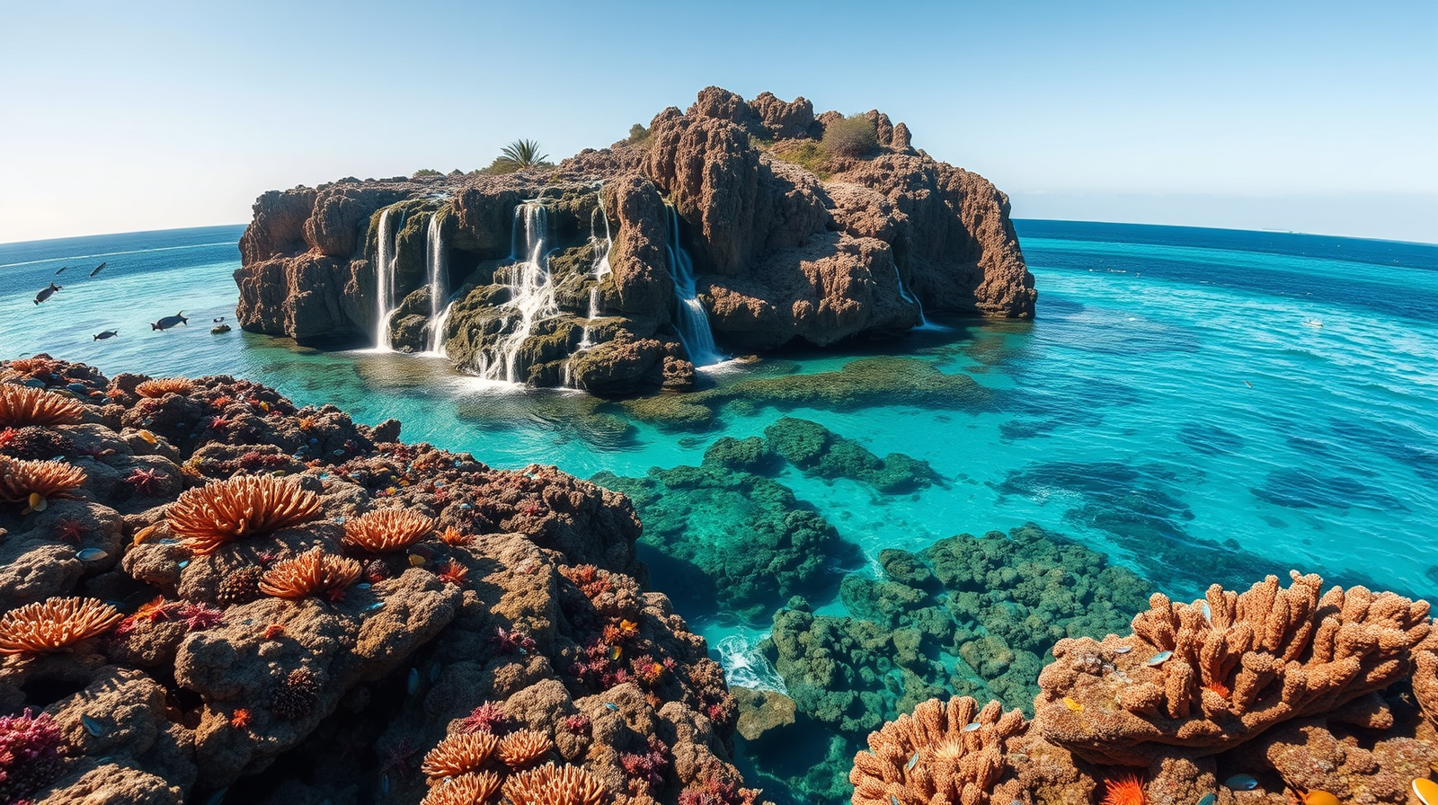
Montgomery Reef, situated in the Kimberley region of Western Australia, experiences extreme tidal movements caused by astronomical alignment, regional bathymetry, and coastal resonance. The semi-diurnal tide cycles in the King Sound and surrounding Camden Sound produce vertical water shifts exceeding 10 meters (33 feet). This hydraulic variance transforms a submerged marine ecosystem into a temporarily exposed landmass covering approximately 400 square kilometers twice every 24 hours.
The physical phenomenon relies on three distinct hydro-geomorphic variables: Meanwhile, you can find related developments here: The Sky After the Ash Settled Over Jakarta.
- Macro-Tidal Amplitude: The geometry of the northwest Australian continental shelf accelerates water velocities as ocean currents funnel into shallow coastal margins, amplifying standard lunar tides into extreme macro-tidal shifts.
- Perched Water Table Dynamics: The reef structure consists of a raised outer rim composed of crustose coralline algae, carbonate sand, and coral skeletal matrix, enclosing a shallow central lagoon system.
- Differential Drainage Rates: During the ebb tide, open ocean water levels drop faster than the impounded water within the central lagoon can escape through narrow drainage channels.
This hydrostatic head—the elevation difference between the trapped lagoon water and the receding sea level—generates torrential outward streams. Water spills over the reef perimeter, creating hundreds of continuous, temporary waterfalls around the entire structure.
Morphological Architecture of the Perched Lagoon System
The structural profile of Montgomery Reef differs fundamentally from typical offshore barrier reefs or low-lying micro-atolls. Its spatial layout determines both the duration of exposure and the velocity of the resulting water runoff. To understand the full picture, check out the recent analysis by The Points Guy.
+-------------------------------------------------------------+
|                      HIGH TIDE PHASE                        |
|  ~~~~~~~~~~~~~~~~~~~~~~~~~~~~~~~~~~~~~~~~~~~~~~~~~~~~~~~~~  |
|  [ Outer Ocean ] -- [ Reef Rim ] -- [ Shallow Lagoon ]     |
|  (All elements completely submerged under 3-5m of water)   |
+-------------------------------------------------------------+

+-------------------------------------------------------------+
|                      EBB TIDE PHASE                         |
|                                     [ Shallow Lagoon ]      |
|  [ Outer Ocean ] <=== Waterfalls ===| (Perched Water)       |
|  (Dropping Fast)                    [ Elevated Rim ]        |
+-------------------------------------------------------------+
The Peripheral Terraces
The outer margins consist of stepped terracing made primarily of biogenic limestone and rhodolith beds. As the tide recedes below the crest of these terraces, water falls outward across multiple levels, dispersing kinetic energy across a broad perimeter rather than a single cliff face.
Drainage Channels and Micro-Estuaries
Inside the platform, a network of erosion channels acts as micro-estuaries. These channels concentrate thousands of liters per second into fast-moving rivers that cut through the carbonate platform. Flow velocities inside these primary channels routinely exceed 8 to 10 knots during peak ebb movement.
Substrate Composition
Unlike standard living coral gardens dominated by delicate branching Acropora species, the intertidal zones of Montgomery Reef are dominated by heavy-calcium-carbonate-encrusting organisms, turf algae, and resilient macroalgae. Delicate coral architectures cannot survive the mechanical stress of falling water or prolonged direct atmospheric exposure.
Ecological Energy Cascades and Trophic Inversion
The daily emergence of the reef forces a severe periodic restructuring of the local marine food web. Where standard open-ocean systems maintain relatively constant trophic interactions, the rapid drop in water level triggers a hyper-concentrated feeding window.
Tidal Ebb Begins
  └── Ocean level drops below reef rim
        └── Perched lagoon trapped; water spills over edges
              └── Small fish/crustaceans swept over perimeter
                    └── Apex predators congregate along drop-off zone
                          └── Seabirds exploit surface turbulence
Prey Trapping and Transport
As lagoon water evacuates through the drainage networks, millions of small teleost fish, crustaceans, and invertebrates are drawn toward the edge. Unable to swim against the accelerating hydraulic gradient, these organisms are propelled off the platform into the surrounding deep-water channels.
Predator Aggregation Tactics
Large marine predators organize around predictable points of hydrodynamic discharge:
- Tide-Line Hunting: Blacktip reef sharks, whitetip reef sharks, and giant trevally align themselves along the base of the waterfall curtains, capturing disoriented prey as it exits the lagoon.
- Aviation Exploitation: Sea eagles, kites, and terns target the shallow channels and exposed reef flats, feeding on organisms stranded in isolated tidal pools before the water fully drains.
- Benthic Foraging: Green sea turtles and egrets move along the newly dry substrate, grazing on exposed algae or exposed invertebrates trapped in micro-depressions.
This system creates a localized, high-yield energetic transfer point. The energy gathered within the 400-square-kilometer lagoon platform during high tide is filtered through discrete drainage channels within a brief three-to-four-hour window, concentrating biomass into accessible zones for higher-order consumers.
Operational Constraints for Marine Expedition Logistics
Navigating and observing a macro-tidal runoff zone requires precise calculation of hydrographic variables. Operating vessels in proximity to Montgomery Reef involves significant hazards due to extreme current shifts, submerged obstacles, and localized fluid turbulence.
Hydrographic Survey Requirements
Charted depths in macro-tidal zones change rapidly within short timeframes. Depths listed on nautical charts represent Lowest Astronomical Tide (LAT). A location showing 2 meters of water at LAT may hold over 12 meters at High Water Springs, fundamentally altering navigable passages hour by hour.
Vessel Positioning Strategies
To maintain stability and safety, expedition vessels must adhere to specific spatial protocols:
- Upstream Staging: Vessels must anchor or hold position on the windward and current-ward side of the reef structure to prevent being drawn into discharge channels or grounded on falling tides.
- Tidal Flow Thresholds: Tender boats navigating near the reef edge must maintain positive propulsion relative to current speed, keeping a clear buffer zone from the waterfall lip to avoid localized down-drafts and surface aerated water (which reduces hull buoyancy).
- Time-Window Calculation: The optimal observation phase occurs during the middle two hours of the ebb tide, where the hydrostatic height differential between the internal lagoon and the open sea reaches its maximum without fully depleting the lagoon volume.
Calculate local tidal curves using spring-neap variance figures before planning any marine approaches. Deploy tenders only when current velocities remain below 5 knots within primary access channels, and maintain a minimum distance of two vessel lengths from active water-drop margins to prevent steering loss in aerated discharge zones.