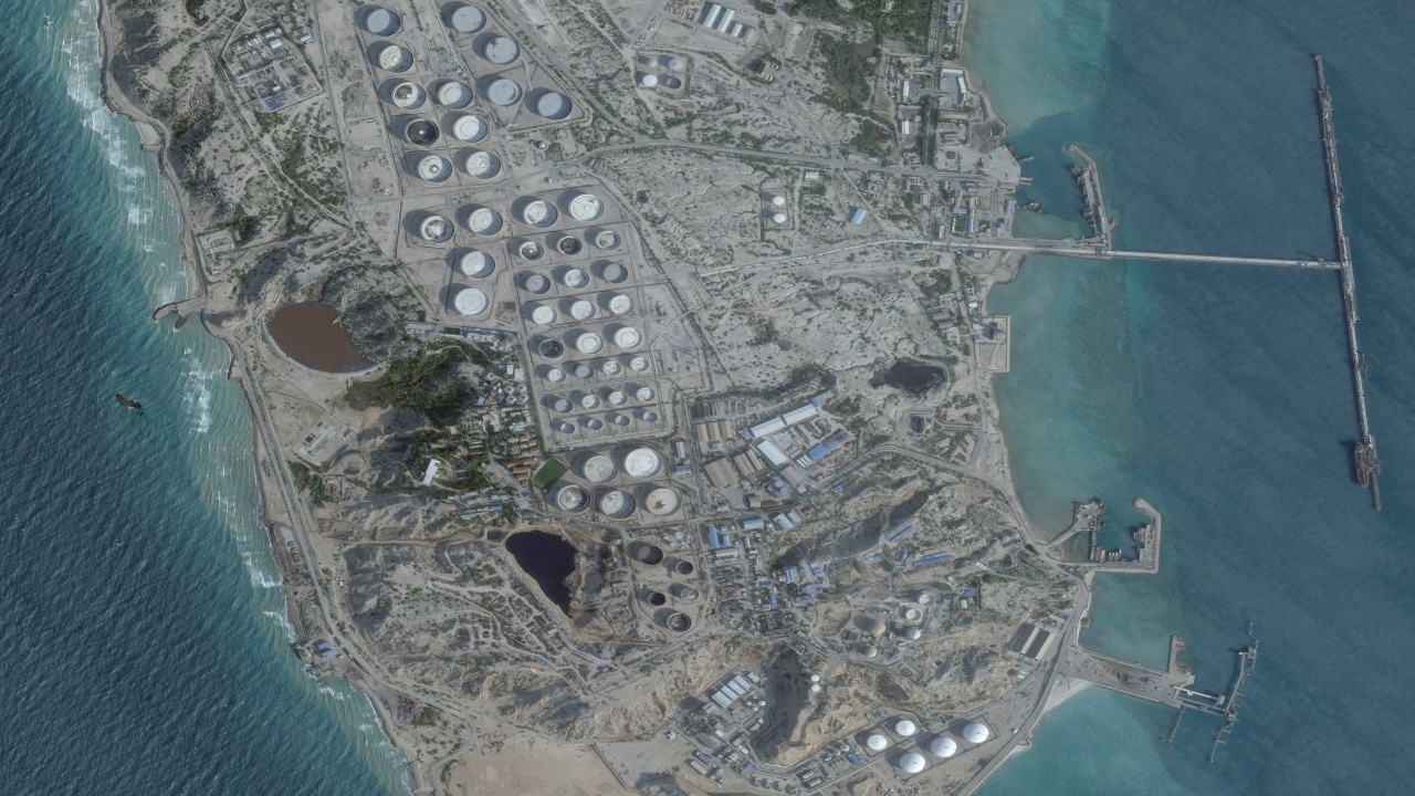
The operational proposition to deploy ground forces to seize and occupy Iran’s primary energy export hub, Kharg Island, operates on a fundamental miscalculation of asymmetric theater dynamics. While executing an amphibious or airborne assault to neutralize existing localized resistance is well within the technical capacity of the United States military, transitioning from a rapid kinetic capture to a sustained territorial occupation alters the entire strategic calculus. Holding an isolated landmass positioned deep within an adversary's primary strike envelope introduces an severe asymmetric vulnerability: it transforms an offensive asset into a static, highly concentrated target for mainland saturation strikes.
To evaluate the strategic viability of this operation, the tactical reality must be separated from political rhetoric. Kharg Island, encompassing an area roughly one-third the size of Manhattan, sits a mere 16 to 21 miles off the Iranian mainland. This tight geographic proximity subjects any occupying force to a continuous, compressed timeline defense model where the standard warning buffers required for integrated air defense systems are structurally neutralized. By examining the mechanics of anti-access/area denial (A2/AD) saturation, the logistical physics of island insulation, and the economic feedback loops of infrastructure weaponization, we can map the exact friction points that make a physical takeover a net-negative strategic play.
The Geometry of Saturation: The 20-Mile Defense Bottleneck
The defining variable of a Kharg Island occupation is its proximity to the Iranian coastline. This spatial configuration creates a compressed defense window that fundamentally challenges modern point-defense systems, including Patriot batteries and land-based Phalanx systems (C-RAM).
[Iranian Mainland Battery] ---> 16-21 Miles (Sea Gap) ---> [U.S. Forces on Kharg Island]
                                                            Low Radar Warning Horizon
                                                            Terrain Masking (Zagros Coast)
This geographic proximity impairs defensive operations through specific technical mechanisms:
- Radars and the Horizon Limit: Standard ground-based air defense radars operating on a flat island surface face a line-of-sight horizon bottleneck against low-altitude threats.
- Terrain Masking: The mountainous topography of the Iranian coastline allows low-flying cruise missiles and loitering munitions to utilize terrain masking, emerging from mountain passes directly over the coast and minimizing the detection window to under 60 seconds.
- Asymmetric Cost and Inventory Depletion: Neutralizing low-cost loitering munitions and first-person view (FPV) kamikaze drones requires interceptors that cost significantly more than the incoming target. In a high-frequency saturation environment, the localized magazine depth of an island garrison will inevitably face depletion faster than the mainland can replenish its supply of cheap munitions.
This environment changes the utility of early warning assets. Airborne Early Warning and Control (AEW&C) platforms must operate at a distance to avoid mainland surface-to-air missile (SAM) envelopes. This increased distance degrades their ability to track small, low-radar-cross-section targets moving over complex coastal terrain. Consequently, the garrison on the island is forced to operate under a continuous, high-probability threat of terminal engagement, turning a defensive outpost into a high-risk position.
The Garrison Paradox: Personnel Mass vs. Target Density
Sustaining a secure perimeter on Kharg Island requires balancing two conflicting operational needs: the troop density required to defend the island versus the vulnerability that density creates.
+-------------------------------------------------------------------------+
|                        THE GARRISON PARADOX                             |
+-------------------------------------------------------------------------+
| Higher Troop Density                                                    |
|  ---> Required for perimeter security & infrastructure defense          |
|  ---> INCREASES target profile for mainland ballistic/drone saturation  |
+-------------------------------------------------------------------------+
| Lower Troop Density                                                     |
|  ---> REDUCES target profile and potential casualty numbers             |
|  ---> LEAVES critical oil infrastructure exposed to unconventional raids|
+-------------------------------------------------------------------------+
To secure an area of this scale against unconventional infiltration, combat divers, and localized sabotage, military planners estimate a baseline requirement of 800 to 1,000 ground troops. However, this deployment footprint generates a secondary vulnerability:
The Concentrated Target Profile
Placing a concentrated force onto an island lacking geographic depth creates a highly lucrative target profile for long-range artillery and ballistic missiles. Because the island's primary infrastructure—including oil storage tanks, pumping stations, and sea-island terminal jetties—is fixed and unhardened, troops cannot be effectively dispersed without placing them adjacent to volatile industrial assets.
The Hostage Analogy
Rather than acting as a power-projection node, the garrison effectively functions as an institutional hostage. The adversary does not need to launch an amphibious counter-invasion to neutralize the U.S. presence; they only need to maintain a low-intensity, continuous bombardment using guided sub-munitions to inflict regular casualties, knowing that every American loss carries disproportionate political and strategic weight.
The Propaganda Vector
The integration of FPV drones carrying high-definition optical feeds introduces a significant information-warfare risk. Successful terminal strikes against U.S. personnel or key equipment can be captured and disseminated globally in near-real-time, shifting the strategic narrative from one of decisive U.S. power projection to a visible war of attrition.
The Logistical Friction of Island Insulation
A military force is only as resilient as its supply lines. In the case of Kharg Island, the logistics chain required to sustain an isolated garrison must transit through the narrow waters of the northern Persian Gulf, an environment characterized by extreme maritime choke points.
A primary risk is the exposure of sea lines of communication (SLOC). Supplying an island garrison with food, water, ammunition, and replacement parts requires regular littoral transit. These support vessels must operate well within range of coastal anti-ship cruise missiles (ASCMs), fast attack craft (FAC) swarms, and smart sea mines. Securing these logistics runs demands a continuous commitment of naval escorts, drawing critical surface combatants away from broader regional missions.
Air-bridge vulnerabilities also complicate support efforts. While tactical airlifts can bypass naval mines, transport aircraft face high risks during their approach and departure phases. The proximity of the mainland allows man-portable air-defense systems (MANPADS) and mobile short-range air defense units deployed along the coast to target slow-moving transport assets. This threat forces air supply operations to rely on night windows or complex electronic warfare support, restricting the volume of supply delivery.
Finally, the island’s domestic infrastructure introduces serious sustainability challenges. Kharg Island lacks independent freshwater generation capable of supporting an active military garrison alongside the remaining civilian maintenance population. With regional desalination infrastructure vulnerable to kinetic disruption, the U.S. military would be forced to import water supplies, adding a heavy logistical burden to an already vulnerable supply line.
Infrastructure Attrition and Strategic Futility
The core policy objective behind seizing Kharg Island is to control Iran’s primary economic lever—specifically, the energy infrastructure through which approximately 90% of its historic crude oil exports flowed. However, the economic mechanics of this strategy contain a fundamental flaw: the asset cannot be preserved while simultaneously under constant bombardment.
+--------------------------------------------------------------------------+
|                     INFRASTRUCTURE ATTRITION LOOP                        |
+--------------------------------------------------------------------------+
|  U.S. Seizes Kharg Island to Control Oil Export Revenues                 |
|       |                                                                  |
|       v                                                                  |
|  Mainland Fires Artillery/Missiles at the Island                         |
|       |                                                                  |
|       v                                                                  |
|  Industrial Infrastructure Damaged Beyond Immediate Repair               |
|       |                                                                  |
|       v                                                                  |
|  Strategic Asset Liquidated; Revenue Halts, But U.S. Troops Remain Stuck |
+--------------------------------------------------------------------------+
Petroleum export infrastructure is structurally fragile. The massive loading arms, complex manifold systems, and large storage tank farms are highly susceptible to thermal and kinetic damage. A single strike from a low-cost munition can ignite a localized fire capable of destroying a pumping station, rendering the entire facility inoperable for months.
Consequently, an adversary facing the loss of its sovereign asset has little incentive to leave it intact. By targeting the very infrastructure the U.S. seeks to secure, mainland forces can neutralize the economic value of the island while leaving U.S. forces with the burden of occupying a damaged industrial landscape. This outcome deters potential commercial tankers from approaching the zone, completely halting export revenues without achieving the intended leverage of operational control.
Furthermore, this operational model fails to address alternative transit infrastructure. While Kharg Island handles the vast majority of deep-water tanker traffic due to shallow coastal waters along the mainland, targeting or occupying it does not entirely eliminate Iran's energy options. Smaller, distributed overland pipelines and smaller coastal barges can shift flows to alternative, less efficient export terminals or regional processing hubs, diluting the economic impact of an island-specific campaign.
Alternative Framework: The Offshore Interdiction Model
When contrasted with the compounding risks of a physical ground occupation, an offshore maritime interdiction model offers a more scalable approach to achieving the identical policy objective: halting the flow of sovereign energy revenues.
+-----------------------------------------------------------------------+
|                    OFFSHORE INTERDICTION FRAMEWORK                    |
+-----------------------------------------------------------------------+
| Operational Mechanism:                                                |
|   - Stand-off naval blockades placed outside the Persian Gulf         |
|   - Satellite tracking and VBSS (Visit, Board, Search, and Seizure)   |
+-----------------------------------------------------------------------+
| Strategic Advantages:                                                 |
|   - Zero static ground troops exposed to mainland artillery           |
|   - Maximizes warning windows for naval air defense systems           |
|   - Scalable intensity based on geopolitical escalation dynamics      |
+-----------------------------------------------------------------------+
An offshore strategy avoids the vulnerabilities of static positioning. By utilizing a combination of satellite reconnaissance, unmanned surface vessels, and stand-off naval assets positioned outside the immediate littoral strike zone, the U.S. can establish a flexible blockade. Instead of attempting to control the physical terminals on Kharg Island, forces can intercept, board, or turn back international tankers attempting to depart the northern Gulf.
This approach alters the tactical dynamics in favor of defensive systems. Naval surface combatants operating in open water maintain full radar visibility, maximizing their warning windows to defeat incoming threats. More importantly, this model avoids placing a fixed target on the ground, denying the adversary a high-value propaganda vector and keeping U.S. personnel out of range of short-range coastal artillery.
Ultimately, an offshore interdiction strategy provides a scalable option. If diplomatic negotiations advance, the blockade can be adjusted or lifted immediately without the logistical challenges of executing a military withdrawal from occupied territory. If escalation continues, the pressure can be maintained indefinitely without risking an isolated ground force to a costly war of attrition.