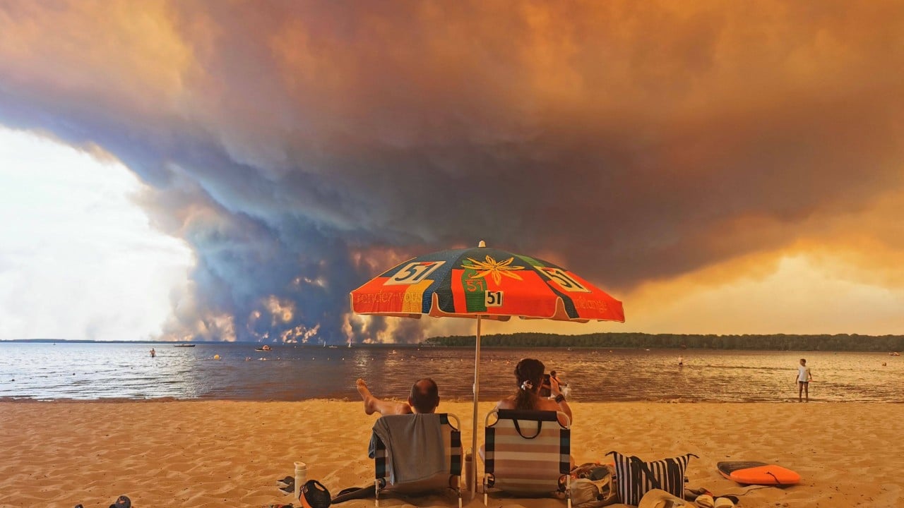
When a wildfire grows large enough, it stops reacting to the atmosphere and starts manufacturing its own. This is not hyperbole. It is a terrifying meteorological reality that changes every rule emergency responders rely on.
Decades of studying natural disasters taught me one constant rule: severe weather drives fire. Wind fans the flames. Drought dries the fuel. Low humidity turns timber into kindling. But extreme fire behavior breaks this directional flow entirely. A catastrophic blaze can generate enough thermal energy to punch through the troposphere, spawning massive convective clouds known as pyrocumulonimbus, or fire thunderstorms.
These cloud formations do not just drift overhead and rain. They act as engines of destruction. They suck oxygen into the core at hurricane speeds, hurl glowing embers miles ahead of the main front, and—most dangerously—discharge erratic dry lightning that ignites entirely new secondary blazes.
The Thermodynamics of a Monster
To understand how a routine timber fire transforms into an atmospheric anomaly, you have to look at the sheer physics of heat transfer. Fire is chemical oxidation releasing stored solar energy. When millions of acres burn simultaneously, the sheer volume of rising hot air creates an intense updraft.
Air expands as it heats. This buoyant plume rises rapidly, carrying ash, smoke, and water vapor thousands of feet into the upper atmosphere. As this column reaches freezing altitudes, moisture condenses around the ash particles acting as cloud condensation nuclei.
This rapid condensation releases latent heat. That additional thermal injection acts like a turbocharger on an already roaring engine, accelerating the updraft even further. The cloud towers upward, sometimes punching past thirty or forty thousand feet, creating its own anvil head just like a severe summer supercell thunderstorm.
When the Sky Strikes Back
The most lethal misconception about wildfire smoke is that it remains passive. It does not. Once a pyrocumulonimbus matures, the internal dynamics shift from creation to retaliation.
The towering cloud becomes top-heavy with ice and water droplets. Eventually, the updraft can no longer support the weight. The system collapses downward, creating a violent microburst.
When this dense column of cold air hits the ground, it spreads outward in every direction. Firefighters call this an outflow boundary. To an observer on the ground, it feels like a sudden gale-force wind hitting from nowhere.
To the fire, it is a supply truck.
The microburst violently slams into the active front, pushing oxygen into the flames and spraying burning brands in a 360-degree radius. A fire that was moving steadily north suddenly finds itself surrounded by spots fires racing east, west, and south.
Containment lines vanish. Evacuation routes close in seconds.
The Lightning Paradox
Perhaps the most insidious feature of these firestorms is their ability to generate their own ammunition. Normal thunderstorms require moisture, temperature differentials, and wind shear to separate electrical charges within a cloud.
Pyrocumulonimbus clouds achieve this exact same charge separation through the violent churning of ash, soot, and ice crystals. The result is frequent, high-voltage lightning strikes that frequently lack the accompanying rain to extinguish what they hit.
Emergency crews tracking a major incident face a cruel math problem. Every lightning bolt dropped by the towering column of smoke represents a brand-new ignition source miles away from the primary perimeter.
During extreme seasons in regions like southern Europe, North America, and Australia, these secondary ignitions have overwhelmed regional civil defense networks. You cannot deploy resources to flanks that are constantly being rewritten by lightning strikes falling out of a smoke plume.
The Blind Spots in Modern Forecasting
Meteorology and fire science have spent decades operating in silos. Weather forecasters study the sky. Fire behavior analysts study the fuel on the ground.
Pyrocumulonimbus events sit directly at the intersection of these two disciplines, exposing dangerous blind spots in early warning systems. Traditional weather radar often struggles to differentiate between a standard rain-bearing cumulonimbus and a smoke-choked pyrocumulonimbus until the anomaly is already fully developed.
By the time satellite telemetry flags the signature anvil cloud, the thermal output below has usually crossed a critical threshold.
Predictive modeling tools are struggling to keep pace with a changing climate. Historical baselines no longer apply when baseline temperatures are higher, relative humidity is lower, and multi-year droughts have cured vegetation down to the root systems.
A forest that would have resisted extreme crowning thirty years ago now vaporizes in minutes, releasing the precise thermal load required to spin up an atmospheric beast.
The Human Cost of Complexity
On the ground, veteran incident commanders are wrestling with a tactical nightmare. Standard firefighting doctrine relies on predictable wind patterns, terrain features, and historical fire behavior tables.
When a fire starts generating its own weather, those tables become useless. Wind speeds shift from a manageable ten miles per hour to erratic, swirling vectors that change direction with the pulse of the upper-level cloud.
Tactical retreats that saved lives in past decades can fail when the sky itself begins raining firebrands behind the retreating line.
We are no longer simply fighting fires on the landscape. We are engaged in a kinetic contest with atmospheric systems that outweigh our suppression capabilities by orders of magnitude. Until our modeling capabilities catch up to the reality of these sky-born monsters, the smoke will continue to write its own rules