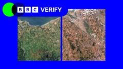
Satellite observation of environmental stress frequently reduces complex meteorological and hydrological phenomena to binary color gradients. When orbital sensors capture the transition of the United Kingdom from verdant green to scorched brown during prolonged heatwaves and droughts, public discourse often focuses entirely on surface aesthetics. This superficial reading masks the underlying systemic vulnerabilities of soil hydrology, agricultural output limits, and urban infrastructure strain. True operational assessment requires moving past visual indices like the Normalized Difference Vegetation Index and dissecting the multi-variable mechanical failures occurring beneath the topsoil.
The Soil Moisture Deficit Function
The primary driver of drought impact is not rainfall absence alone, but the exhaustion of plant-available water stored within the soil matrix. Soil functions as a biological reservoir, and its depletion follows a non-linear degradation curve.
When precipitation ceases and atmospheric demand accelerates via high vapor pressure deficit, root zones experience immediate moisture stress. However, surface satellite imagery typically lags behind actual subsurface deterioration. Chlorophyll degradation and canopy closure reduction register visually only after plants have exhausted hydraulic connectivity with deep soil layers.
The Three Phases of Hydrological Stress
- Phase One: Evapotranspiration rates outpace precipitation inputs, triggering stomatal closure in vegetation to conserve internal moisture. Photosynthesis efficiency drops while surface temperatures rise due to reduced latent heat flux.
- Phase Two: Capillary action fails within fine-textured clay soils prevalent across southern and eastern England. The soil matrix contracts, forming macro-fissures that accelerate evaporation from lower profiles and shear plant roots.
- Phase Three: Complete hydraulic disconnection occurs. Microbial activity plummets, organic matter oxidation accelerates, and topsoil structural integrity collapses, priming the system for severe wind erosion or flash-flood hydrophobic runoff upon subsequent rainfall.
Analyzing these phases reveals why regional drought declarations often arrive weeks after agricultural damage has compounded. Satellite thermal infrared imaging captures land surface temperature anomalies far faster than visible spectrum sensors capture browning, making thermal inertia mapping a superior operational proxy for true root-zone stress.
Agricultural Vulnerability and Crop Yield Elasticity
British agriculture operates within a historical assumption of reliable temperate moisture. Irrigation infrastructure remains sparse outside specific high-value horticultural zones in East Anglia, leaving broadacre crops entirely dependent on natural precipitation and antecedent soil moisture storage.
During acute heatwaves, crop yield elasticity to moisture stress breaks down catastrophically past specific thermal thresholds. Wheat and barley development accelerates abnormally under excessive heat, shortening the grain-filling period and reducing individual kernel weight.
Structural Bottlenecks in Crop Resilience
- Root Architecture Constraints: Soil compaction from heavy machinery restricts root penetration depth, confining plants to the top thirty centimeters of soil where moisture reserves deplete fastest.
- Irrigation Allocation Conflicts: As river abstraction licenses face restrictions during low-flow periods, farmers must choose between deficit irrigation and total crop write-off, altering regional food supply chains.
- Livestock Feedstock Deficits: Pasture productivity collapses under combined heat and moisture stress, forcing early liquidation of herds or expensive importation of supplemental winter feedstocks during summer months.
These operational constraints mean that a visual browning of pastures visible from orbit is a lagging indicator of a multi-year economic shock rippling through feed markets, milk production volumes, and domestic food inflation indices.
Hydrological Infrastructure and Catchment Stress
Urban and industrial water security depends on catchment yield stability, which degrades rapidly during prolonged dry spells. The United Kingdom water resource management framework relies heavily on surface water reservoirs and direct river abstractions, both of which exhibit high sensitivity to multi-month precipitation deficits.
Catchment hydrology responds to drought through a systematic decline in baseflow contribution. Groundwater aquifers, particularly the Chalk formations underlying much of southern and eastern England, provide crucial attenuation during dry periods. However, consecutive dry winters prevent the recharge of these aquifers, lowering the water table below ecological and operational abstraction thresholds.
The Mechanics of Catchment Failure
- Abstraction Limitations: Environmental regulators enforce Hands-Off Flow conditions to protect aquatic ecosystems, forcing water companies to curtail abstractions precisely when consumer demand peaks.
- Distribution Network Stress: Dry, shrinking clay soils exert differential mechanical loads on buried cast-iron and plastic water mains, causing exponential spikes in pipe fracture rates and exacerbating supply losses through leakage.
- Treatment Plant Efficiency: Low river volumes concentrate organic pollutants and industrial effluents, increasing chemical and energy requirements at potable water treatment facilities.
Observing dried riverbeds or shrinking reservoir margins via satellite provides a macroscopic view of surface storage loss, but it obscures the subterranean resilience threshold. Once an aquifer drops past its historical low-water mark, recovery requires multiple consecutive seasons of above-average recharge, a variable completely unaddressed by emergency summer water restrictions.
Urban Heat Islands and Microclimate Amplification
Satellite thermal imagery during UK heatwaves consistently highlights major urban centers as intense thermal anomalies. Concrete, asphalt, and low-albedo roofing materials absorb incoming solar radiation during daylight hours and reradiate it slowly overnight, preventing the nocturnal cooling necessary to alleviate human physiological stress.
This urban heat island effect interacts dynamically with regional drought conditions. Vegetation within urban parks and street trees, stressed by lack of soil moisture, ceases transpiration. Transpirational cooling acts as a natural air conditioner; when urban green infrastructure suffers drought-induced shutdown, the latent heat flux drops to zero, converting sensible heat directly into ambient air temperature increases.
Mitigation Limits and Spatial Constraints
- Albedo Retrofitting: Painting roofs white or using high-reflectivity paving materials reduces surface absorption but does little to resolve the underlying hydrological deficit of urban trees.
- Grey Infrastructure Capacity: Stormwater drainage designs optimized for rapid runoff clearance prevent urban soils from retaining sporadic summer rainfall, accelerating the conversion of precipitation into destructive flash floods rather than sustained groundwater recharge.
Quantifying the true impact of heatwaves on urban environments requires integrating synthetic aperture radar with thermal radiometers to monitor both structural deformation from subsidence and thermal emissivity simultaneously. Visual imagery alone captures only the symptom, leaving planners blind to the underlying mechanical failure of urban microclimates.
Strategic Resource Allocation and Systemic Redesign
Addressing the compounding risks of UK heatwaves and droughts requires abandoning reactive emergency management in favor of structural capital deployment. Current regulatory frameworks penalize water utilities for leakage while underpricing raw water extraction, creating a misaligned incentive structure that discourages long-term network interconnectivity.
Capital must be redirected toward grid-level water infrastructure resilience, including strategic transfer pipelines connecting water-surplus northern catchments to deficit southern basins, alongside localized managed aquifer recharge projects. Agricultural systems require a transition toward drought-tolerant crop varieties, conservation tillage to preserve soil organic matter, and precision drip irrigation systems that eliminate evaporative losses.
Establish regional catchment management authorities with statutory powers to restrict non-essential abstractions before baseflows collapse, and tie agricultural subsidies directly to measurable improvements in soil organic carbon and moisture retention capacity.

/GettyImages-157526585-93425538070d4422ad42d22af28c0758.jpg)